


DOVER TWP DIST 02, York County, Pennsylvania
About
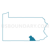
Outline

Summary
| Unique Area Identifier | 664832 |
| Name | DOVER TWP DIST 02 |
| County | York County |
| State | Pennsylvania |
| Area (square miles) | 23.97 |
| Land Area (square miles) | 23.85 |
| Water Area (square miles) | 0.11 |
| % of Land Area | 99.52 |
| % of Water Area | 0.48 |
| Latitude of the Internal Point | 39.99140070 |
| Longtitude of the Internal Point | -76.87991220 |
Maps


Graphs
Select a template below for downloading or customizing gragh for DOVER TWP DIST 02, York County, Pennsylvania


Neighbors
Neighoring Voting District (by Name) Neighboring Voting District on the Map
- DOVER TWP DIST 01, York County, PA
- DOVER TWP DIST 03, York County, PA
- DOVER TWP DIST 04, York County, PA
- DOVER Voting District, York County, PA
- JACKSON TWP PCT 02, York County, PA
- PARADISE TWP Voting District, York County, PA
- WARRINGTON TWP Voting District, York County, PA
- WASHINGTON TWP Voting District, York County, PA
Top 10 Neighboring County Subdivision (by Population) Neighboring County Subdivision on the Map
- Dover township, York County, PA (21,078)
- Jackson township, York County, PA (7,494)
- Warrington township, York County, PA (4,532)
- Paradise township, York County, PA (3,766)
- Washington township, York County, PA (2,673)
- Dover borough, York County, PA (2,007)
Top 10 Neighboring Place (by Population) Neighboring Place on the Map
Top 10 Neighboring Unified School District (by Population) Neighboring Unified School District on the Map
- Spring Grove Area School District, PA (27,384)
- Dover Area School District, PA (25,748)
- Northern York County School District, PA (21,083)
Top 10 Neighboring State Legislative District Lower Chamber (by Population) Neighboring State Legislative District Lower Chamber on the Map
Top 10 Neighboring State Legislative District Upper Chamber (by Population) Neighboring State Legislative District Upper Chamber on the Map
- State Senate District 28, PA (284,462)
- State Senate District 33, PA (280,954)
- State Senate District 31, PA (275,796)
Top 10 Neighboring 111th Congressional District (by Population) Neighboring 111th Congressional District on the Map
Top 10 Neighboring Census Tract (by Population) Neighboring Census Tract on the Map
- Census Tract 207.20, York County, PA (9,461)
- Census Tract 203.20, York County, PA (7,447)
- Census Tract 206, York County, PA (7,107)
- Census Tract 207.10, York County, PA (6,517)
- Census Tract 205.21, York County, PA (5,576)
- Census Tract 205.22, York County, PA (4,085)
- Census Tract 205.10, York County, PA (3,766)